CalTOPO Legend at the bottom of the page
Easting and Northing

UTM Grid Zones of the World

Where am I? Universal Transverse Mercator is a way to answer this question in meters from a nearby meridian.
In the UK: Along the corridor and up the stairs. Easting before Northing.
In the US: Read right, then up.
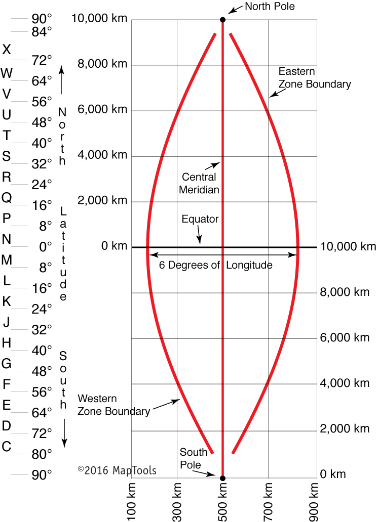
- False easting of 500,000 meters at the central meridian.
- 6° zones. 360/6=60 zones, each with a central meridian.
- For the Northern hemisphere, the equator is assigned a northing of 0 meters. (Assigned to be 10,000,000 meters for the Southern hemisphere – no negative northings.)
- The false values mean there are no negative numbers.
- Zone 1 is between 180° and 174° west longitude.
- Horizontal latitude bands are mostly 8° wide. From 80° S to 84° N. Labeled C to X (I and O are skipped). Band X is 12° tall.
- Laid out in 1,000 meter grids for map scales between 1:24,000 and 1:63,360 (some of these on 5,000 meter grids).
- 1:100,000 and 1:250,000 laid out in full UTM grid or 10,000 meters.
The layout

UTM Grids in the Santiam Pass region

Living on the Edge in 24k
Headed into the rising sun in Eastern Oregon just past the Big Summit Prairie… Zones collide! Its all a matter of perception, uh…I mean projection.
Living on the Edge in 100k
The CalTOPO MapBuilder Info – Legend

On the web
https://upload.wikimedia.org/wikipedia/commons/b/b7/Universal_Transverse_Mercator_zones.svg – image of the UTM system
http://geokov.com/education/utm.aspx
https://www.maptools.com/tutorials?srsltid=AfmBOoqYazq4RKh66Ip4snkwCHj_TYK8ovzT2nxdunY6dSAz3GbyioqM
https://www.maptools.com/tutorials/utm/quick_guide
Math and programming – some serious math ahead!
https://www.movable-type.co.uk/scripts/geodesy-library.html
https://github.com/chrisveness/geodesy/blob/master/latlon-ellipsoidal-datum.js
https://arxiv.org/pdf/1002.1417.pdf
https://www.movable-type.co.uk/scripts/latlong-utm-mgrs.html
Conversion
https://www.ngs.noaa.gov/NCAT/